Setting off
to an island on the other side of the planet that most people cannot even
locate on a map comes with it's own set of expectations. I knew very little
about Tasmania other than that it had a wealth of natural beauty, rocks and
beaches. I decided not to research the history or find detailed information and
rather arrive without such expectations; open armed and explorative. This
turned out to be the right way to travel there.
A flight
just shy of fifteen hours took me to New Zealand where I popped in and out of
the metal flying shells, which continued on to Australia, where I finally
caught my small connection flight to Hobart, the biggest city on the Tasmanian
island. Though weary and jetlagged, I was awake as the plane flew low into the
bay surrounding the city, and the sun peeked through the low hanging clouds
shining divinely on the water, illuminating the hills that rolled in shades of
green all around the conjoining bays. It
was immediately clear I was landing in a place of great beauty. I have a
certain amount of anxiety writing about my experience of the island as it feels
impossible to encompass it's beauty into black and white type on a digital
white page. The best I can offer is a trip report and snippets about the nature
lover's paradise.

The crew
was five, Jerry, Preston, Max, Ben and myself. The first night we stayed in
Hobart, a clean city that wraps around the bay, which cuts into the southern
part of the island and resembles a small Geneva without the mountains. Our contact
Simon had a large map of Tasmania on the wall and we spent a good deal of time
poking at it, googling the different locations we wanted to explore. After a
day of shopping and waiting for my lost luggage, we loaded our ridiculously big
rental van full of food, our multitude of bags and set out towards Ben Lomond
national park.
Jerry
became designated left-side driver, and he did a great job, only nearly killing
us once. Four hours of driving lead us through a landscape resembling the
central coast of California; rolling hills covered in Eucalyptus forests, some
trees reaching far higher than any of the same species in the States. Green prairies lined the
road, often full of happy gray sheep grazing or lounging.
Small farm houses
appeared, pastel yellows and green, picket fences, white decorative edging
around the porches and occasionally a stoic horse standing in the back garden.
The small towns always had old tractors, vintage gas stations and at least one
cafe and bakery. I had been advised early on to eat as many savory pies as
possible, and judging from the free roaming sheep my choice of lamb and
rosemary pie had been right. It was delicious. The pies are flaky, golden brown
crusts with chunks of meat and thick sauce inside. At about $4 American it was
hard to resist.
Thanks to
GPS we knew we had arrived, as there was no kiosk or border to the national
park. We had taken several dirt roads and watched as the Eucalyptus gave way to
pine and rocky, red soil. We turned down another dirt road and drove as far as
the van would, sliding a bit on the rocky two-track. We sorted gear, most of
which was lightweight amsteel slings, soft shackles, rope protection, and of
course tri-cams and the slackline itself. We could see the towering cliffs just
above the tree line and we suspected there would be a lot of highline
potential, but it was still difficult to determine exactly what we might need.
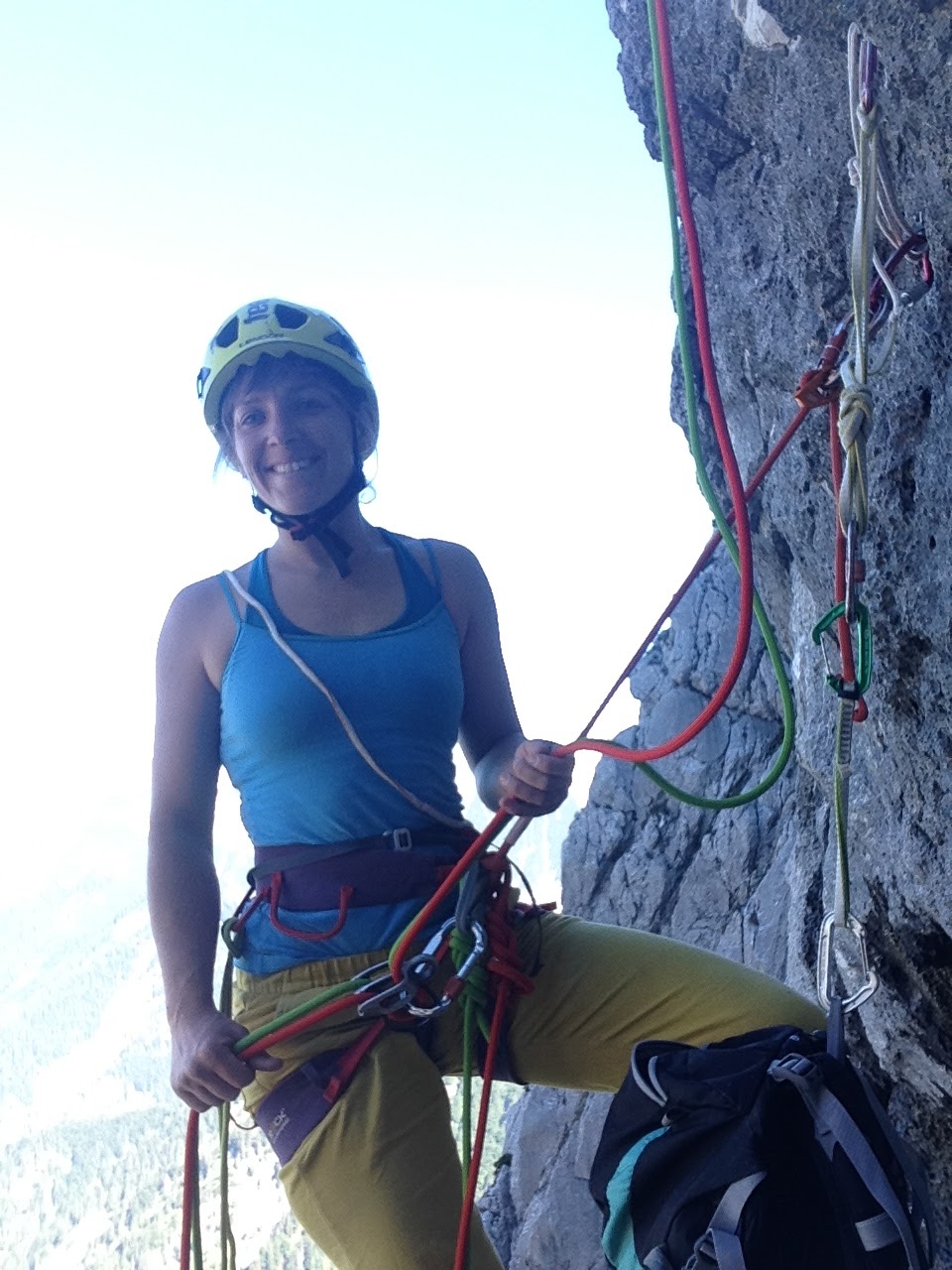
A special aspect of the trip was that there was no drilling involved; all
anchors would be natural and removable. It is a great ethic albeit time
consuming. We had the lightest gear possible thanks to Ben, and I couldn't
imagine doing the same thing with heavy spanset's and steel shackles.


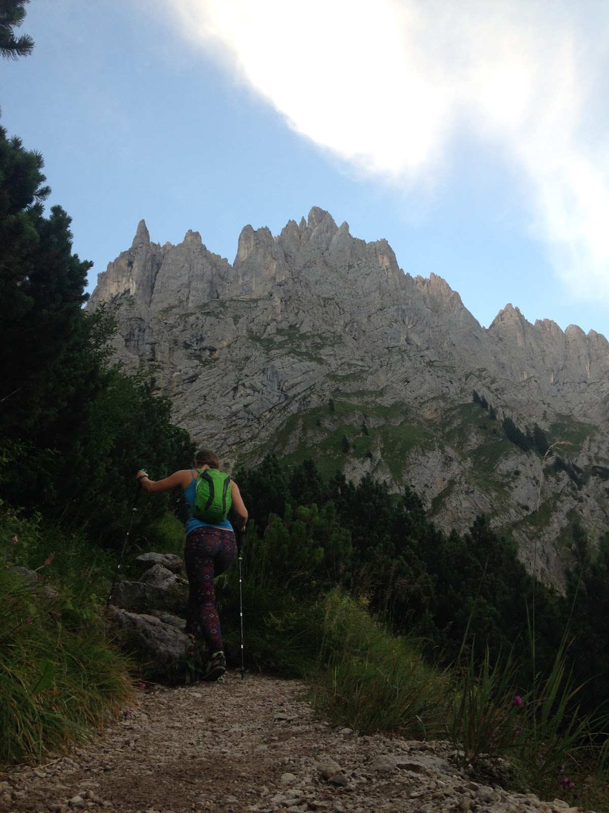
The trail
wound through a sparse forest, with massive gray, smooth trees standing like
grandmothers of the wild. On the trail, thick bushes overgrew the path and a
certain amount of force was necessary to navigate them. The path steadily lead
upwards, eventually opening up to a lichen covered scree field that ran along
the base of the cliffs as far as we could see. Water was a necessity, and
though we knew there was a tarn nearby, we weren't sure where we could access
the cliff top. During the hike the clouds had silently glided in, surrounding
the rocks and pregnant with water. Rain was coming. There appeared to be a
scree covered gully leading up to the top, and Preston ran ahead to scout it,
and eventually we were all following up the boulder field. We ascended into the
clouds, eventually reaching a plateau that stretched as far as we could see.
There were a few clearings in the bushes where we set up our tents, Jerry off
in his one person, me with my Big Agnes two person (for my backpack and I) and
the rest of the boys in Max's dyneema teepee. The sun was nowhere in sight and
we were in a gray fog, our clothes immediately wet. It was how I imagined
Ireland or Scotland; vast plateaus of dense green brush and a magical mist
hanging over everything. We all gathered in Max's teepee where Preston
suggested a percussion party. Collecting all pots and pans within the vicinity,
we spent the remaining hours banging on orange juice bottles, pans, stoves and
the like, and catching whatever giant spiders wandered in.

My first
mistake was leaving my rain pants back home. The second mistake was wearing my
approach shoes and leaving my mountaineering boots in the van. My feet and
pants were soaked from the get-go, and without sun I had no chance to dry them.
Despite the poor weather conditions we hiked up to the edge of the cliff and
began searching for gaps. The cloud ruined our chances of seeing the exposure,
however we knew the cliffs were sheer and the highest points were around 200
meters from the scree field below. Near camp we found two possible gaps, small
distances but aesthetic. We spent another several hours traversing the cliff
edge as it went up, then down, then up again. Most of the way I could walk
along the rock slabs, but at times I found climbing up the easy class five was
quicker. The rock in Ben Lomond is Dolerite, a type of basalt almost like granite
but with super friction. Even when wet I didn't slip a single time. After
spending almost the entire day looking around, we chose the first gap we'd seen
and slowly made our way back.

Jerry was
able to gain service and check the weather, and it looked bad for another day.
We discussed leaving and returning, but the boys touted their love of
suffering, so we rigged in the rain and wind. Max and Preston rappelled on the
far side to reach the pillar that would be our anchor. They used the 100-meter
static rope to wrap several pillars and eventually we had an anchor and a
backup. On the tensioning side, Ben, Jerry and I searched for natural anchors
for a long time. The way the rock slabs angled towards the cliff edge made it
difficult to sling them, as they had no edges to hold the Amsteel against. Some
hours later we managed to sling a free standing boulder and a big pillar quite
far back from the edge, and then we ran Amsteel all the way to the drop off,
using tri-cams for a directional. It was not simple rigging and entailed a
number of rope protectors to prevent rock abrasion. The weather remained
heinous and it was a constant sideways thin spray of water, so we finished the
rigging and retreated to camp.

The next
day was even worse. We walked up to the line and tried to finish the last
touches of rigging, but eventually all agreed it was time to bail until the
conditions improved. We packed up our wet tents and hiked back down to the van.
After descending several hundred meters the weather improved vastly, and by the
time we were in the forest near the car it was barely sprinkling. The top of
the cliff was so lost in the cloud we were just experiencing something entirely
different up there. So, we spread out our stuff to dry, battled land leeches,
and waited for the sun.


Our last
day was blue skies and sun. We took daypacks and hiked up to the line, and
though the wind was brutal, the line was so loose that once it was weighted the
walker couldn't feel the wind whipping over the plateau. After three days we
were able to officially establish our first highline in Tasmania. We each took
our turns, enjoying the short but beautifully exposed line. Around 100 ft long,
it sloped up to a pillar on one side and the step off was a challenge but
possible. In a small alcove, the walker feels completely exposed on one side as
the whole valley stretches out for miles. From the far side the beautiful tarn
is visible, a blue-green circle of shallow, crystal clear water.

We detoured
to the Bay of Fires for one night, hearing it was a must see destination. We
ate pizza on the beach whilst being eaten by sand fleas. We drove up and down
in the dark searching for a place to sleep, finally finding a turnoff. I walked
along a sandy trail and pitched my tent sans rainfly just behind a grassy dune,
keen to sleep to the sound of waves crashing against the sandy shore. My tent
has a really neat feature of LED lights inside, and usb or batteries

can power
them, so I plugged in my GoalZero Venture battery pack and immediately found myself
illuminated. I read late into the night listening to the ocean. At sunrise I
heard Max pattering by and I awoke, joining the boys on the beach as the sun
crested the horizon. From the wet, soggy Alpine environment to the white sand,
turquoise water of Bay of Fires was a small taste of the diversity Tasmania
offers.
The following day we headed
south towards the Tasman Peninsula. Along the way the map was repeatedly taken
out and our group discussed where to go. There were too many options and
imposing weather, so we expected only brief windows of time. It was agreed upon
to go to Cape Raoul since no highlines had been established there. The
landscape gradually changed; the colors became more what I imagined in
Australia; dryer beige grasses and auburn fauna, still met by dense Eucalyptus
forest. We passed small, quiet towns with unusual names like Eagle-Hawk Neck
and Nubeena, finally arriving at the end of the road.

The cliffs were out of
sight, we were on the peninsula itself but it was wide and encompassed
farmlands and villages. It was growing dark, and next to the trail there stood
a beautiful two-story house on a hill, surrounded by a large green open field.
Signs along the fence invited respectful hikers to use the composting toilet,
and we soon figured out that it was a privately run campground. The owner came
to the fence and told us the fee; $5 AUD per night, and twice that if we wanted
to use the sauna. We drove our van in and pitched our tents in the field
amongst the wild hens that roamed and screeched all around us. They look quite
like a chicken only thinner and more athletic. The many geese added to the
choir making quite a racket all around us, it sounded like a jungle of poultry.
Andy, the
owner of the campground was friendly and inquired about our plans. He had seen
our highliner friend printed in the newspaper prior to our arrival and had an
inclination as to what we were planning. He offered to hike water out for us.
These unexpected kindnesses are part of why I love traveling so much. Once our
bags were packed with one night of food and all potentially necessary highline
equipment, we started up the trail that started at the dead end of the road and
quickly lead us into another forest. We crossed logs, wound through mossy
eucalyptus trees, and eventually landed at a cliff edge exposing the endless
dark blue of the ocean. I was reminded of the Calanque in Southern France.

On
we trekked, now moving downward through stubby old dead trees and thin trunked
new ones. Soon we opened up onto the plateau of the peninsula, and the bush
bashing began. No trees dotted this landscape, just endless shoulder or head
high bushes, thick and rugged. Once we reached the end of the trail we split
off and dumped our packs and searched for our gap. Separately we found several
options; a big hundred meter projects in an alcove on one side, a sixty-meter
gap with sheer two-hundred-plus drops below it, and we all eyed the towers
below us in a formation called the wedding cake, named for the candle like
spires dotting the small finger of the peninsula. There appeared to be a lot of
potential down there so Max and I rappelled in to scout while the rest of the
crew rigged the sixty meter gap.

We spent
the next several hours scrambling along a slippery traversing climbers trail, dirt
sliding, off-width down-climbing, repeatedly looking at Max's iPhone picture of
the Wedding Cake attempting to gain bearing. He used my Tendon Lowe 8.9 rope to
lead an unknown crack on an unknown tower so we could gain a vantage point, and
upon reaching the top we found a lack of rap rings and we were no closer to the
gap we had seen from above. The greatest difficulty was how off level all the
spires turned out to be. We finally found a second trail that lead to the base
of a small tower, which involved a short solo traverse, one that I was happy to
have climbing shoes for.

The rock was some of the most friction I'd touched,
ever. My skin was raw after one hand jam. Eventually we talked logistics and it
was clear getting everyone down there with all the equipment would be a feat,
and we still didn't know how to get a connection between one tower and another
with sheer drops straight the ocean below the gap. Though we bailed without a
new project it was a fun scouting mission.

Several hours later we rejoined
the group and found a beautiful new line rigged and almost ready for walking.
It went from edge to edge with quite creative rigging.
When I asked them what
they had slung on the other side, Ben answered "Everything." The
alcove it was rigged in was a V shape, gradually opening up to a wide mouth
exposing waves crashing against rocks far below. The cliffs on the peninsula
are long hexagonal pillars, rising out of the ocean in short heights and
eventually reaching up three hundred meters. The drop below the highline was impressive. I scrambled to a freestanding pillar some hundred feet back to watch Jerry
cross. He slowly and steadily stepped his way across the loose line. The
weather was the opposite of Ben Lomond; the sun beat down and caused lethargy
and sunburns all around. When I finally scooted out on the line the wind was
gusting sideways and making the highline buck and kick like a wild snake. I
gingerly made my way to the middle and fell, then repeated my mistake. The
scouting mission had used quite a lot of my energy bank and I retreated to the
rock to lie down and bask. Later after the wind subsided a bit I got on the
highline again and managed to cross it. The exposure was breathtaking. Though
far below, the movement of the water was a present distraction.

Before dark
we returned to our bivy spot, and I utilized the strong sun to charge my dying
electronics. With direct sun my phone was charged in less than half an hour,
and I wondered why I had waited so many years to utilize the suns energy! That
evening we camped on the peninsula, nestled in the bush and blanketed by a
million stars. The following day we de-rigged the line and hiked back through
the bush, the sweeping branches of coastal pine, the mossy forest, and finally
found ourselves back at the campground for a night. The owner Andy let us look
at his maps of Tasmania as we plotted our next destination. We learned more
about his plans for the beautiful house; that it would be a bed and breakfast
and small farm. They were already producing organic garlic and jams. The house
was an incredible work of art; all wood and sustainably built, with a wood
burning stove that heated the water while heating the house. Tasmania is famous
for it's wood and the house was a perfect exhibit of that.

The next
day we drove to the Devils Kitchen, a popular tourist destination where a large
arch has been eroded by the saltwater of the ocean slapping against the cliff.
Next we drove to the blowhole, a stinky and unimpressive spot where water
smashes against a natural tunnel spraying brown rotting-kelp water into the
air. The best part about the blowhole is a nearby food-trailer, serving fish
and chips, pies, and fresh berry ice cream. Following the map and assuming
where the cliffs would be, we drove up a dirt road into the Tasman Peninsula
National Park and parked at the end. We walked about a hundred feet to the edge
of the viewpoint and found ourselves staring at a perfect alcove. Jerry's laser
told us the gap was over ninety meters. We ran around the edge of the cliffs
searching for any other coves that could offer other possibilities, but
ultimately agreed on the ninety-meter gap. After our last highline missions,
rigging a line a short walk from the van was a luxury! We divided to conquer
and I began helping weave a tag line through the bushes and trees inside the
cove. The anchor on one side was a tree with the edge of the rock slung as a
directional.

The stinky ants we had encountered all around the island were in
this area also, and quickly invaded our rigging process. On the other side the
sturdy railing of the viewpoint became the tensioning side. Not long after we
were pulling our slackline across the gap, and true to the style of the trip it
remained loose and droopy.
A tourist
woman asked Preston about our activities and presumed that we would pull rocks
off the cliff and destroy the natural surroundings, and it can be assumed she
is the same person who called the police on us. While Jerry smoothly crossed
the line the local police officer slash ranger showed up and took a gander. He
was friendly and didn't care in the least that we were highlining.
The line
was easy for Jerry and Ben, however the rest of us fought on it. Though the
length is well within my abilities, transitioning to loose lines is still a
mental battle and physically perplexing as I try to let go of my old technique
of controlling every shake, and rather learn to sway as the line sways, and
take a step when it calms down. This line was no less frustrating, particularly
knowing that some tension would make it far easier for me. I accepted my plight
and took several turns walking, falling, standing up, walking, falling, repeat.
A couple of the guys fetched fish and chips from the food trailer and we
happily gobbled them up sitting on the edge of the cliff, staring at our
highline and the beautiful endless ocean.

We stayed
the following day enjoying the sunshine, explaining to tourists what we were
doing, watching the tourist boats pull up below us and point as someone slowly
crossed the line. The overall alcove was huge, and across from our little gap
was at least four hundred meters in distance. The rock cliffs were different
from the hexagonal pillars of Cape Raoul; rather they were horizontal layers
upon each other, as if a cardboard architecture model of the coast had been
blown up to life size. Atop the cliffs was a vast Eucalyptus forest, and had we
followed the Waterfall bay trail no doubt we would have found more alcoves to
highline in. It felt endless. Potentially the only thing Tasmania is missing
other than Mexican food is a solid highline community.
Jerry was
leaving a week earlier than the rest of the group so we drove back to Hobart
for a night to regroup and decide what the rest of us wanted to do with our
time. There are some impressive alpine environments in Tassie, however access
is long and we were unsure if we had enough time left to get anything done. I
was dreaming of Federation Peak, however the seven-day access sounded touch
with a backpack full of highline equipment, and yet it was difficult to leave
without seeing the islands most impressive environment.
A session of google and
showing each other photos of the options lead us to Lake St. Claire National
Park. Previous to our arrival parts of Tasmania has been through some terrible
fires, and not everything was reopened. We drove for several hours, and for the
first time passed landscapes that were not lush. The hills looked barren, with
an occasional singular white, dead tree clinging loosely to the hillside. A
half dry cattle pond, a barbwire fence and a small white farmhouse with peeling
paint were at times the only sign of habitation. Gradually the landscape became
greener, and the trees became thicker, and soon we were in a dense forest of
tall trees, seemingly impenetrable other than our two-lane road passing
through. It was the first time we drove at night, and as the sun set the
animals began crossing; wallabies, wombats, devils, possums, it was a miracle
we didn't hit one. It was the most wildlife we had seen on the entire trip. The
wombat looked like a small, furry VW bus, and the devil was much smaller than I
imagined.

We slept on
a fire road off the main. The next morning we headed to the park, the sky was
gray and rain seemed imminent. We had to take a ferry across the long stretch
of the Lake St. Claire. It was expensive, however the six-hour hiking
alternative would add quite a bit of time to our trip. We bought our tickets,
and then packed our bags for a three-days in the bush. There was no way to make
them light; we had lost one of our companions and we had to take food, camping
equipment, climbing equipment and highlining gear. We boarded a small boat with
a few hikers and puttered across the lake. It was a landscape from the Pacific
northwest; dark water surrounded on all sides by dense forest. Classified as
sub-alpine, not only eucalyptus trees live here but beech and a number of
ancient pine variations. The peaks were
hidden in heavy, wet clouds but we knew they were there. We stopped at one of
the huts on the Overland Track, a popular eighty-kilometer hiking trail, and
stepped off the boat to have a look. We continued on until we reached the Cessiphus
hut near the ferry dock, where a crew of wet and forlorn looking hikers awaited
their boat back to civilization. No doubt we would look the same in a few days.

Our packs
were upwards of sixty pounds, and we hoisted them onto our backs and set off
down the well-marked trail. The forest was less dense and it quickly opened up
into button grass plains. A well-built boardwalk wound through these grasses,
allowing us to hike above the marshy, wet ground beneath. I was impressed that
such a rural and hard to reach park was so well maintained. After seven years
of hiking my butt off for highline excursions, it finally dawned on me to
listen to an audiobook while walking. I am kicking myself for taking so long to
reach this conclusion. With a story in my ears, time flew by. My surroundings
transitioned from grassy open marsh to a mossy forest, magical neon red lichens
growing up the green fuzzy trees, and the mossy boardwalk appearing as if it
had always been there. The forest was darker and darker, and soon there were
strange prehistoric-palm-tree-looking plants that gave the impression of
dinosaurs about. This was the lost world. We arrived at Pine Valley Hut, our
stopping point that night. I slept in the hut on a wooden platform, my Big
Agnes Sleeping pad and sleeping bag keeping me warm and cozy but not protecting
me from the snoring bear inside. The hut was a common stopping point on the
overland track and it had four other hikers sharing the space. Due to
aggressive mice, I hung my aircontact pro from the rafters to protect my food.
The boys stayed in the teepee outside, where they were visited from a number of
creatures in the night.

The
following day we set out to hike towards Mount Geryon, our highline
destination. Some Russian highliners had established a beautiful line there
already, and we planned to either repeat their line or establish a new, bigger
line above it. The hike from the hut quickly became steep and bushy, and I
grunted up the slope until I reached a small plateau. From there I could see
the deep valley we had just hiked out of. We had to skirt around the entire
valley to reach Geryon, and it looked far and impassable. The path led down the
other side of the plateau, where a number of twisting lakes were visible. I
walked along the shallow lakes, beautiful alpine bodies of water not more than
a few feet deep. Then I entered the Labyrinth; a confusing collection of rocky
mounds sprinkled with skeletal eucalyptus trees. In the distance a giant set of
cliffs with obvious highline potential beckoned, while across the valley the
gap of Geryon looked more and more appealing. Though rugged, wild and hard to navigate,
this park was full of potential.

Eventually we all reached the saddle between
the Geryon side of the valley and the Labyrinth, where the guidebook had
mentioned a climber's camp. Water was of no issue; tons of small pools were
scattered across the rocky slope. There were so many types of mosses, some firm
and spiky, unflinching after stepping on them. Others were soft and lush,
harboring water. We scrambled across the area searching for a flat spot without
water trickling across it.
The boys
found a teepee spot with a beautiful front porch overlooking the entire valley,
the twisting lakes, the Labyrinth, Lake St. Claire and the endless peaks and
cliffs in the distance. A level above I found a flat rock, and set up my
FlyCreek tent. Though the tent is for two, it is so light I would happily pack
it for myself on another trip, and having space for my pack and still plenty of
room for myself was a luxury as well.

There is
something so poignant about being in these undisturbed natural environments; the
Cradle Mountain area of Tassie is famous for being inhospitable, a title
arrogant humans would give a landscape that doesn't bend to their will. Besides
the well-groomed path and a peppering of huts, the landscape seems greatly
untouched. There are cliffs as far as the eye can see, with no paths to them.
The adventurous and ambitious highliner, climber or BASE jumper could open many
a route or exit, and yet, it is unlikely to be repeated. Once humans find a
landscape that bends to their will, a road goes in, a parking lot, a trail, a
signpost, a view point...it never ends, and some years later impact becomes an
issue. I stood on the precipice of my short-term home and imagined aboriginals
passing through the landscape; hunting, sleeping by the stars, bathing and
drinking from the lake, and doubtfully did they ever think about how to make
the land yield.
We followed
the trail from our bivy as it gradually inclined and passed through another
plateau, this one carpeted in the most beautiful moss I'd ever seen. Oval
blankets of green, firm speckled peat lay scattered across the steppe, and I
had to touch it. Upon closer inspection each type of moss was it's own
beautiful geometric work of art.

Cairns marked the path but they seemed to
disappear and reappear unexpectedly. We were on our own, for the most part. We
couldn't see the gap and it was a wild guess as to where we could summit.
Scattered, our group followed the many trails through bushes, over scree, and
up gullies, occasionally doing easy climbing moves with our heavy packs to
reach what appeared to be the easiest ascent. We huffed and hauled ourselves up
dihedrals, grabbing at roots and cracks. It was easy, but adding forty or more
pounds of gear complicates easy scrambles, to say the least. Once on top we
ventured around the boulder field to the edge, and found ourselves staring at a
perfect gap. It appeared level, and the exposure of both valleys dropping to
the sides of Mount Geryon and the impressive cliffs of the Acropolis in the
background were breathtaking.

It was late
in the day, and a discussion of what was feasible took place. Our climbing team
felt uneasy about some recent rock fall on the route they needed to ascend to
reach the other summit, and our uncertainty about weather the following day
left lingering doubt. The reality of going on trips with a group is hearing and
respecting each person's opinions, concerns, desires and needs. Despite all
sharing the same passion, it is unrealistic to think that four people would
always be in agreement. The big gap was beautiful, and desirable, but
pressuring those responsible for climbing to that side didn't feel right, and I
was concerned about leaving the line up in case we had to de-rig the following
day in bad weather, especially considering the approach was slippery and
involved some climbing moves. Our alternative was to repeat a beautiful and
aesthetic line established by some Russians earlier that year. It wasn't quite
what we came to do, however it was beautiful and worth a walk. While Preston
rappelled he carried a thin cord, our tagline for making the connection over
the gap. He then climbed up the small middle tower, flicking the tagline over
edges so that it hung free. Attached above my ledge, Ben had to walk the static
rope along the edge, trying to keep it from hooking on any cracks or ledges,
and then rappel holding the tagline until I could reach into the void and grab
it. Once the boys on the other side were situated, I passed the slackline and
backup rope, pre-taped together, across the gap. We tensioned a bit with a line
slider. The weather had shifted since our arrival, and big, fast moving clouds
sped up the gulley from the valley below and lingered in the gap we were about
to walk across. For long moments visibility was lost and we were in the gray
and white no mans land of the mountains.

When the clouds cleared enough to see across
the valley, the twisting lakes of the Labyrinth reflected the patches of
perfect blue sky. It looked as if the world was indeed flat and the lakes were
windows through the crust to the sky below.
With limited day
light we delegated tasks quickly. Our climbing team rappelled to climb a small
tower in the gap that acted as one anchor of the line. I scrambled down to a
small ledge covered in scree and boulders to sling a large rock that would be
the other anchor. The rock was huge, and I had to wiggle up a wet chimney to
get the sling around one side, then climb up the other side to finish circling
the rock. Protection for the sling was very important in this scenario, as the
boulder had sharp edges.

Ben walked
the line first, slowly and steadily crossing it in his usual fashion;
effortless but as slow as a snail, wearing his little leather shoes. I took my
turn and struggled, finding my legs fatigued and my mind distracted by the
swirling fog. It had been at least six years since I had fought on a line so
short, and though I aimed to attempt it with no expectation, the crushing fear of
failure hung heavy upon my shoulders. It is so easy to become attached to our
performance levels, and when circumstances lead to us performing worse than we
did in the past, it is a tough part of our ego's to battle. I crossed almost to
the half and fell, repeatedly. The loose type-18 highline with dynamic rope
backup wobbled under my feet and I seemingly couldn't calm it down. At some
point I scooted off of the line for the other boys to give it a shot, in
disbelief at my own inability to cross it.

The day was
drawing to a close and the sun, though invisible behind the overcast sky, was
dipping low behind the blue hills. We didn't have much time left. I scooted out
for one last attempt. I fell in the same place as every other time, just before
the half. I attached my line slider and glided to the far side, the tower, and
moved my body into the chongo position. The clouds were a bit less thick, I
could see the other side, and I stood up focusing on the technique that was key
to crossing successfully. I remained with straight posture, hips equalized over
the line, trying to slow all movements down and transfer those movements to the
line so it remained calm as well. Halfway across the tiredness set in and my
mind was screaming at me to give up. I screamed back, verbally shouting,
"Come on!" the phrase so often mentioned in my trip reports.
Near the
end of the line I was trying to remain calm and collected while also
envisioning how I should step off onto the uneven rock surface. It was a slab
and my depth perception was skewed from focusing so hard on the anchor. I tried
to step off, losing my balance and almost face planting to the shocked faces of
the boys watching. I managed to block my face with my elbow, forunately. My
swollen elbow became a lovely reminder of the fight, and I laughed out loud,
ecstatic to have sent the line.

We
de-rigged as quickly as possible, losing light fast. We fashioned a tyrol for
Max to get off the tower without ascending, then carried all gear to the summit
to pack our bags. By the time the whole group was ready to depart, it was
headlamp hour. The fog has resumed its position in full force, swallowing us
and allowing only ten to fifteen feet of visibility. According to the first
Cairn, we tied our static rope to some routes and rappelled the down-climb
section, now soaked and slippery. We continued on the small trails, Max quickly
outpacing us, his lamp just as quickly disappearing into the dark mist. The
path seemed much longer than we remembered, and it became a game of "find
the Cairn," which started us off confidently until we lost the trail and
found ourselves standing on the edge of a cliff peering into the black. It took
hours before we arrived wet and tired at our campsites, wearily flopping down
on the stone porch by the teepee and cooking a late dinner. My beet, carrot and
quinoa stir fry, though heavy to carry tasted well worth the effort.

The following morning we slept in, eventually
rising to a crisp blue sky. Alas, it would have been fine to leave the line up.
A group of ten or more hikers passed our camp, and an eager woman quickly
ventured towards us to ask how many times we had walked the line. Camping by
the lake, they had witnessed our entire highline fiasco, from set-up, walk, to
the late night shenanigans of finding our way back. The sound had apparently
traveled across the valley, and I wondered how many hikers we had kept awake
shouting, "Max! Where are you?!" We mentioned our epic return, said
farewell and they continued on. The hiking
group was a mix of older folks, no one younger than fifty and some looking
easily seventy or more. We all felt hardcore by our own rights, and yet an hour
later I peered up to see the entirety of the hiking group standing a top Mount
Geryon. A hiker I repeated this story to later would say, "Sounds like the
Hobart Bush Walkers, they are pretty hardcore."

I was keen
for a rest day, but the rest of the group was eager for another highline, so we
walked to the top of the plateau we were camped upon and agreed upon a
sixty-seven meter long gap. With little expectation, I enjoyed walking on the
line, but enjoyed sleeping on the mossy tufts far more. I was saddened later to discovered that the moss is extremely sensitive and dies after being touched. There is now possible a Faith-shaped dead moss outline on one of the beds. We enjoyed one last
sunset in one of the most beautiful places on earth; a fiery display of neon
orange fading out from the peaks, wispy clouds circling them.

The
following day I rolled up my Big Agnes tent, mostly dry, and stuffed the Ethel
sleeping bag deep into my pack. Somehow, despite eating most of my food (which
I had had to ration an extra day) my pack was the same weight as the hike in.
We trekked back to the dock where we had arrived a few days prior, jumped in
the lake to reinvigorate our weary bones, and watched as platypuses swam by the
banks. The next morning the ferry arrived to carry us back to our van, full of
food. Rationing three days of food into four had left me with not even a cashew
to my name, and I was famished.

Our trip
was nearing an end, but we had time for one more project. Uncertain if the time
frame would allow an explorative mission, it was decided to repeat a beautiful
seventy-meter highline that our friend had established on the Moai, a classic
tower off the coast of the Tasman Peninsula. The weather did us no favors, the
clouds hung low and pregnant with rain, and the wind whipped around the coast,
gusty and unpredictable. Nevertheless, we packed our gear and hiked the hour
and a half in, than rappelled to a ledge to rig. I climbed the tower with
Preston, enjoying a fun and easy single pitch route up varying cracks on the
backside of the Moai. Impressed with the friction, I was immediately sad that I
hadn't climbed more during the trip.
The line
was not high, but it was aesthetic. There is something special about walking
towards a tower, as if the Creators left such stone figures just for highliners
and climbers to enjoy. The waters of the Pacific swelled up around the base,
crashing against the kelp-covered rocks, spraying white sea foam into the air.
Despite the overcast skies and wind, we all enjoyed our time walking on the
line, trying to adapt as unexpected gusts hit from every direction.

Hiking
back, I went ahead of the group and resisted using a headlamp until I saw
nothing. No moon was visible behind the clouds and no stars guided my way. I allowed
my eyes to adjust, making out shapes of fallen trees or switchbacks through the
Eucalyptus forest enough to stay on track. I heard rustling all around me,
certain that wallabies were hopping around the perimeters of the trail. Finally
it was too dark to see, and I succumbed, pulling my lamp out and turning the
bright LEDs on. Immediately animals scurried off into the grass and trees, a
wallaby hopped away, a lizard slithered under a rock, and there in front of me
the cutest possum I've seen clung to a small tree, blinded by the light. I
stood still, and the little guy crawled down to the path, and walked right up
to me, lightly scuttled over my feet, and continued on his way.
When I
finally reached the beach and the path curved down into the soft white sand, I
yanked off my approach shoes and socks, rolled up my pants and immediately
immersed my feet in the lapping waves. As the water coated the sand then
retracted to where from it came, it seemed the stars were being reflected in
the wet sand; bioluminescent organisms glowed all along the border of wet and
dry sand, it was one of the most beautiful things I've witnessed.
My last two
days were spent being hosted by a wonderful couple, the parents of a gal I'd
met while Climbing in Mexico a month prior. They lived in a beautiful, handmade
wooden house, overlooking a small bay with occasional surf. I went out for a
paddle with Jill, wishing I had more time to explore all the surf Tasmania has
to offer. It is clear to me, that to live in Tasmania is to be close to nature,
to have good coffee and savory pies whenever you may choose, incredible
seafood, and the ability to disappear into true wilderness.
With only a few
weeks I barely scratched the surface of this incredible piece of land, and I
hope to return in the near future. Highlining was the point of the trip, and
yet it was far from the meat and bones of the adventure. Easily eighty percent
of my travel on the island was spent hiking through an array of landscapes,
microclimates changing from one turn to the next. The wildlife is everywhere
you turn, a wombat crossing the road, a wallaby hopping off the trail or a
possum peering down at your camp from a tree branch. The entire landscape
evoked memories of Central California, where I called home for three years, but
with huge cliffs and mountains thrown in. The small towns and pastel farmhouses
with sheep roaming free feel like a scene from an idyllic European summer, and
the bakeries and coffee houses are a reminder of the inhabitant’s British
origins. If you don't mind bush bashing, long approaches, traditional climbing,
creative rigging and unpredictable weather, than I cannot recommend Tasmania
more. I look forward to my return.